Washington D.C Historical Tour

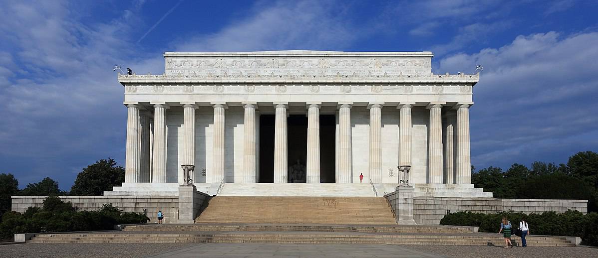
This is a tour of the National Mall in Washington D.C. The Mall is composed of museums, monuments, memorials, and government buildings. With this map, I want students to be able to explore all of the different aspects of the Mall. If students are not able to physically go there, then they can still see what is around. Or if we are able to plan a trip to the Mall, then we as a class can plan where we want to go and how we will get around.

I believe that this would be a great resource for students when they are learning about American History. Broken up by layers on the map, students can be broken up into groups and they can research different aspects of the mall: the government buildings, monuments and memorials, and museums. Through this research students can deep dive into why these aspects or specific parts are included and why they are important to American History. Each students will become their own expert in the specific part that they research, and can share their findings with the rest of the class.

Artist Research Tours

This map shows important locations for three different artists. I thought this could be a fun, interactive way for students to do a research project! My intent is to have students follow the tours and look at the locations for each artist, then have them choose one to do further research on. This map is more of an interest grabber for the kids, rather than a place for them to solely base their research upon. Eventually, students will create their own map with important places for the artist they chose. I think in the future I could add more artists, or even branch out and do different historical figures. This process made me think more about how I will explain the globe to my students. It’s kind of a strange concept to think about, and I think that this visual of the map will help!

Mountains in Washington State

This lesson was created for upper elemenatry students to explore the mountain peaks in Washington State. Included in this tour are the four tallest peaks in Washington state along with Mount St. Helens. Each scene has an included point of interest with information about the elevation of the corresponding peak.

Students will be able to observe the mountains and surrounding terrain using online tours. Students may be asked questions posed by teacher or interact in a classroom discussion.

Featured Image: Kranich17

My dream science museum tour!

I created a map to showcase some of my favorite science museums in the United States. I haven’t been to most of these museums, however, one day I hope to explore all of them!

I really liked learning how to use MyMaps! I’m definitely going to use this tool to explore cities and places that I visit when I travel.

Educational Activities for Kiddos MyMap

person on swing

Below is a Google MyMap created as a resource for families to take their young learners (Pre-K-1st grade) in free time that act as not only fun things to do, but educational opportunities. I believe that children learn best through play, so many of these locations are designed for place based learning, but there are also a volunteer opportunity and a craft supply store. One layer of the map will show outdoor locations, while the other will show indoor locations. It would even be fun to pitch a field trip idea around one of these experiences!

Photo by Annie Spratt on Unsplash

Explore the Outdoors in Oregon

Authors: Kali Tagomori-Lai and Allie Haakenson

This interactive map will help students (2nd-3rd grade) to understand that there are many outdoor parks that are located in Oregon. The students will be given this map as an instructional piece to help them identify just a few of the state and National parks in Oregon.

They will then be asked to take this map and figure out the distance between their school and the listed state parks. They can also find other state parks that they can identify. At the end, they will have a writing prompt about the outdoors/ nature and submit it for credit.

https://unsplash.com/photos/A–cz3cxstI

Let’s Learn History!

This activity is meant to introduce different historical aspects located right here in Portland while simultaneously providing the students with visuals. The virtual tour contains 6 different historical sights all within the greater Portland area. By introducing the students to just a few important places throughout history, they are able to gain a little more insight about the area they live and the importance of each place in Portland history. This activity can be used as a basic intro to these sites at a 1st grade level or could used as a precursor to a more in-depth lesson on a specific place within the tour.

Image Source Pixabay

Discovering Changing Environments

Image of Glacier National Park in Montana

This digital tour is designed to take children to a variety of different places that illustrate the ways in which changing climates and human driven pushes for development have changed different physical landmarks and environmental systems. The map includes 360 photos of different areas for the students to explore, as well as links with images to what the region used to look like, or images to help build understanding. The description of each image also comes with the web address of the information included, to encourage the students to dive deeper into learning about these specific areas.

This activity is designed for upper-elementary students, and could serve a variety of purposes in the classroom. It could serve as a way to help students practice their researching skills and evaluating information. Teachers could break students into four groups (one for each location) and have the groups practice researching in print and online sources to find more information about these locations, and why the region is shifting in the specific ways that it is. Science teachers could also use this as a great way to begin discussing the ways in which human actions impact the environment, and help students to fully immerse themselves in a shift that has been slowly occurring over time.

Let’s Go to the Zoo!

Kids peering over and through an exhibit fence

*Note: Click the icon in the upper left corner to filter the different layers. Select the Expectations and unselect the Overview to view the information for the students. Doing the opposite will show the information for the chaperones.

This map is designed as a preview to a field trip for kindergartners. The map consists of two layers, one for the students and one for the parents. The layer labeled field trip expectations contains information for the teacher to share with the students. I would use this layer of the map as part of a lesson in field trip expectations prior to the trip. The information on this layer outlines what behavior is appropriate for the field trip and emphasizes that these expectations are to keep them safe. It will also give the students an idea of what our field trip to the zoo would look like in terms of transportation and a schedule. The other layer of the map is for the chaperones with details regarding their responsibilities as a chaperone and the details of our transportation.

In thinking through this map, I really like the feature of different layers so that you can filter different information. Since I want to give different information for the same location, this feature allows me to view the different information by selecting only one layer. I also think this tool is very helpful for this type of a map because I can share it with the chaperones so that they have access to it on their phones and can reference it as needed. It was somewhat time consuming to make, but with practice I think the process will go quicker. And I think, especially in terms of a kindergarten field trip, the time put in would be worth a smooth field trip.

Featured Image: Photo by H W on Unsplash

Community Lesson- San Ramon, CA

Using Tour Creator I have created a virtual tour of some key places in San Ramon, CA. This could be used in a community lesson to show students different places in the city they live and provide new information about those places. If this is a decided activity to do in the classroom, the students could create their own tour of the places they think of as their community.

Featured image by Drei Kubik on Pixabay

Basketball Travel

This post is a map of all the different schools in the West Coast Conference. These are all schools that we as a basketball team travel to in order to play these schools. This was helpful in learning how to use a map to demonstrate different places for different things!